See road map here.
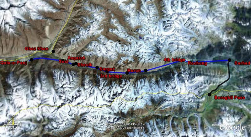
Qala-e-Panj to Sarhad-e-Boroghil (blue route)
In case road conditions do not allow you to drive all the way to Sarhad, you will have to walk between Qala-e-Panj and Sarhad-e-Boroghil. It is an easy 3 to 4-day hike along the Wakhan river, crossing friendly Wakhi villages and offering exceptional views of high mountains such as the Baba Tangi (6 507 m). There are two ways alongside the Wakhan river: the south bank way and the north bank way. Although you can walk on any side of th river (there are four bridges crossing the Wakhan river between Qala-e-Panj and Sarhad-e-Boroghil that allow you to go back and forth between the north and south banks), the north bank is the most used route and the most advisable.
The first night may be spent in the village of Sheulk. People are friendly and there is a small guesthouse. The highlight of Sheulk is its hot spring located at a 30 mn walk uphill. The hotspring is really warm, clean and is a great opportunity to take a bath. It also offers nice views of the Baba Tangi. A small contribution is appreciated to keep the hot spring clean and running. It seems that the hot spring can also be reached from Sargaz, one hour after Sheulk eastwards.
The second night may be spent in either Rorun or somewhere between Rorun and Rochung (a night out may be necessary as there is no lodging option between Rochun and Rorun). Spending the night in Rorun may oblige you to spend 3rd night in Rochung before reaching Sarhad-e-Boroghil at the end of the 4th day. In order to cover the journey in no more than 3 days, you will have to spend the night out.
A few hours before getting to Sarhad, the valley suddenly widens out and forms some kind of a broad basin. Sarhad lies at the very end of the Wakhan valley, exactly at the limits between the three highest mountain ranges in the world after the Himalaya: the Hindu Kush, the Pamir and the Karakorum.
If you do not have mules or horses of your own, starting in Qala-e-Panj, you may have to change animals and guides at least four times before getting to Sarhad: in Ouezet, in Sheulk, in Rorun and in Rochung. It is better if you can manage to get the guarantee in Qala-e-Panj (from the Shah) that you can keep the animals and the guide all the way to Sarhad.
In Sarhad, you may stay at the Tajik-style 'guesthouse' run by the local leader. An alternative is to stay in the newly-built school. There is another hot spring in Sarhad, the last one before Ararkar in the Little Pamir. Sarhad is a good base camp for further exploration: Pakistan is only a few hours walk southwards, the Little Pamir is a few days walk eastwards and the Big Pamir is 3-day walk northwards.
Sarhad to Boroghil Pass (Pakistan) (black route)
It is a 6-hour or so hike between Sarhad-e-Boroghil and the Boroghil Pass (3 798 m) into Pakistan. Enquire in Sarhad for more details. There are many other passes between the Wakhan and Pakistan. See the Afghanistan-USSR 1983 International Boundary Study for more details. The report mentions the Darwazo Pass, the Kankhun, the Ochhili, and the Shahgologh, all of which lead to Chitral. West of the Corridor there are many other passes, including the Anoshah, the Kotgaz and the Qazi-Deh Passes.
See road map here.