See road map here.
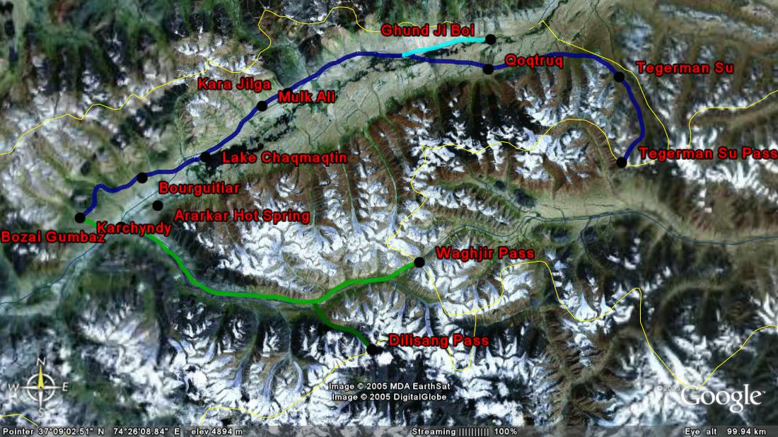
Karchyndy to Waghjir Pass (China) (green route)
Although we did not cover this route, converging testimonies suggest that it takes 3 to 4 days to reach the Waghjir Pass (4 923 m) from Karchyndy via Buzai Gonbaz and the Waghjir Valley. The source of the Oxus is located on the way (see John Mock and Kimberley O’Neil’s report). The Waghjir Pass is the gateway to Xinjiang (China). It is strictly off-limit to any traveller.
Karchyndy to Tegerman Su Pass (China) (dark blue route)
According to Matthieu Paley, it is possible to reach the Kotal-e-Tegerman Su (possibly also called Yuli Pass, 4 872 m) into China in 4 1/2 days via Kara Jilga and Qoqtruq (place of Rani Boi, last yurts of the Little Pamir, opposite Ghund Ji Boi area). The Tegerman Su Pass is the easternmost part of the Afghan Pamir.
The area that starts immediately after Lake Chaqmaqtin is called Manara. It goes all the way to the end of the Little Pamir (Tegerman Su) following the Murghab River with Qara Qorum in the South and Andemin in the North.
Karchyndy to Ghund Ji Boi (Tajikistan) (light blue route)
Converging testimonies suggest that it takes one day to Lake Chaqmaqtin, one day to Kara Jilga (where Abdul Rashid Khan, the current leader of the Little Pamir lives), and two days to Ghund Ji Boi near the border with Tajikistan. On the Tajik side, the border is called Kyzylrabot. There is an old road that runs from Kyzylrabot all the way to Buzai Gonbaz.
There are at least two other passes that mark the border with Tajikistan half way between Kara Jilga and Ghund Ji Boi northwards: Kotal-e-Djamanag Shur (or Jaman Shur) and Kotal-e-Ortobil (or Qabrestan-e Ortobil). The Jaman Shur is mentioned in the Afghanistan-USSR 1983 International Boundary Study as well as another pass called the Andaman/Andeymin/Andemin Davan. Both are said to be leading to the Big Pamir (Zor Kol). The border at Ghund Ji Boi is closed to foreigners. Read Mark Jenkins' report to see what it takes to cross illegally the Afghan/Tajik border in Ghund Ji Boi.
Karchyndy to Dilisang Pass (Pakistan) (dark green route)
According to John Mock and Kimberley O'Neil's, it seems that it takes 2 to 3 days to reach the Dilisang Pass (5 290 m) from Karchyndy via Buzai Gonbaz and the Kamansu Valley. See their expedition report to the Dilisang Pass for more details. The "Delhi Sang Pass" is also mentioned in the Afghanistan-USSR 1983 International Boundary Study.
There is another pass to Pakistan located between the Boroghil Pass and the Dilisang Pass called Irshad Uween. It was crossed by John Mock and Kimberley O'Neil as well as Matthieu Paley in 2005. This pass was also used by Philippe Valéry in 2001 according to his book Par les sentiers de la soie: à pied jusqu'en Chine. The Irshad Uween Pass lies at the end of the Bai Qara Valley via Adina Boi at the South East of Langar (near an area called Tash Koprouk). The Afghanistan-USSR 1983 International Boundary Study mentions the Irshad Uwin Pass as well as two other passes in this area leading to Hunza and Gilgit: Khora Bort Pass and Garzan Pass.
See road map here.